The Nazca Lines
A hummingbird. A monkey. Trees and flowers. Why were more than 350 of these images, some visible only from the air, etched into the soil of the Nazca Desert of Peru? How were these geoglyphs created across roughly 200 square miles, beginning more than 2,000 years ago? What purposes did these lines and images serve? These are the questions raised by the Nazca Lines. Now a UNESCO World Heritage Site, the lines were carved by the Paracas and then the Nazca cultures over a period of more than a thousand years.
This archaeological enigma is the largest collection of geoglyphs in the world, and the meaning and purpose of the symbols has been a subject of debate since Spanish conquistador Pedro Cieza de León wrote about them in 1553. Although he initially described the lines as trail markers — and some do point to water or mark aquifers — speculation about their purpose ranges from the reasonable (the images serve astronomical and religious means) to the surreal (the complex was constructed by aliens and served as an interplanetary spaceport).

The Ghost Ship Mary Celeste
What could be the reason for a crew of seven — along with their well-regarded captain and his wife and young daughter — to abandon a seaworthy ship, leaving behind a full cargo, food, and supplies? That is the enduring mystery of the Mary Celeste, a two-masted brigantine that set sail from New York City on November 7, 1872. Bound for the Italian port of Genoa, the ship was loaded with 1,700 barrels of denatured alcohol.
On December 4, the Canadian ship Dei Gratia found the Mary Celeste drifting near the Azores islands, its main lifeboat missing but cargo and personal belongings undisturbed. Although suffering some minor damage, the craft was sound. Part of the crew from the Dei Gratia sailed it to Gibraltar, where a full investigation was launched. Lurid suspicions about pirates and mutiny and suggestions of giant sea monsters were in abundance, and even Sherlock Holmes author Arthur Conan Doyle chimed in with a short story attributing the disappearance to a vengeful formerly enslaved person. No evidence was found of foul play — nor of any other solid reason for the ship to be abandoned.

The Bermuda Triangle
Countless theories surround the unexplained disappearance of people, ships, and planes in the section of sea that’s a rough triangle between Bermuda, Miami, and Puerto Rico. Especially in the 1970s and ’80s, it was almost impossible to open a magazine or turn on a TV without seeing a breathless article or documentary about the so-called “Devil’s Triangle.” A number of high-profile incidents (including the disappearance of five U.S. Avenger torpedo bombers in 1945) created a near-hurricane of conspiracies.
The region is rife with treacherous reefs, and the Gulf Stream often causes sudden and violent storms. Nonetheless, disappearances have also been blamed on extraterrestrials, secret government plots, Atlantis, wormholes into other dimensions, rogue waves, and undersea methane bubbles. However, the National Oceanic and Atmospheric Administration and the U.S. Coast Guard are clear that there is no evidence that ships or planes disappear more frequently in the Bermuda Triangle than they do anywhere else in the world.
More Interesting Reads

The Mystery of Stonehenge
One of Britain’s most iconic sites, the concentric circles of stone on southern England’s Salisbury Plain are a wonder of Neolithic engineering and an enduring mystery. The humans who began constructing Stonehenge around 5,000 years ago transported some of the massive stones from as far away as Wales, although one of the many legends of its origins says the wizard Merlin was involved.
Theories about the purpose of the site abound. Human remains excavated at Stonehenge predate the current monument, suggesting that it may have originated as a cemetery for the elite. Long supposed to be an astronomical observatory, it draws hundreds of modern-day Druids who come to observe the solstice each midsummer. But recent research has uncovered interesting acoustic qualities as well. The placement of the stones creates an amplification of sound for people who would have been standing inside the circle, while those on the outside would have difficulty hearing music or chanting coming from within.

The Marfa Ghost Lights
Marfa, a small town of 1,700, is now known as an art oasis with quirky installations, but art isn’t the only thing drawing visitors to this dusty spot in West Texas. People from around the globe make the trip, hoping to witness the mysterious orbs of light that flicker and float across the Chihuahuan Desert, 50 miles from the Mexican border. First reported by a cowhand in 1883, the “ghost lights” have drawn the attention of scientists and spiritualists, both hoping to understand the origin of the light show, which usually presents as basketball-sized glowing lights in various colors that dart and dance.
Opinions on the origin of the orbs range from the ghosts of Spanish conquistadors to space aliens (of course) to more sedate sources like ball lightning. Other possibilities include the refraction of light caused by layers of air at different temperatures (often called Fata Morgana), the ignition of phosphine and methane (“swamp gas”), or a type of charge known as piezoelectricity. There’s no definitive answer … and so the pretty mystery remains.

The Depopulation of Easter Island
The remote Rapa Nui (Easter Island) lies 2,300 miles west of Chile. No written historical records exist concerning the island; however, it’s commonly agreed that seafaring Polynesians settled there sometime between 800 and 1200 CE. The island is famous for a collection of around 900 moai statues — stone-carved figures that stand in rows on cliffs, hillsides, and shorelines, most of them with their backs to the sea. The average moai is 13 feet tall and weighs 14 tons; the tallest is a whopping 72 feet high. Archaeologists believe that the colossal statues portray gods and tribal leaders, and it’s thought that ropes and trees were used to move and position the statues upright.
While the moai have long intrigued researchers, the rapid demise and depopulation of Easter Island has puzzled them. When Dutch explorer Jacob Roggeveen arrived here in 1722, he encountered 3,000 or more islanders living in a flourishing and developed society. In 1774, Captain James Cook visited the island and reported around 700 islanders. By 1877, only 111 inhabitants remained. Deforestation, cannibalism, the introduction of the Polynesian rat, warfare, and the slave trade are all possible theories for the dramatic change in fortune; however, anthropological, archaeological, and historical research has yet to uncover the truth.

Houska Castle and the Gateway to Hell
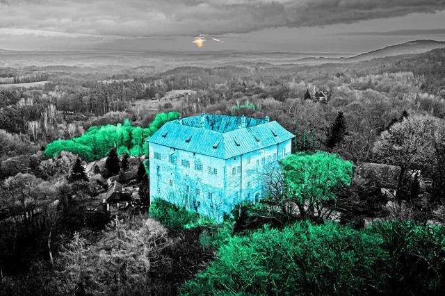
One of the Czech Republic’s best-preserved Gothic castles, Houska Castle stands on a clifftop surrounded by dense forests about 40 miles north of Prague. Built in the 13th century by Bohemian King Ottokar II, the castle subsequently passed between the hands of several aristocratic families. While it appears like a noble mansion from the outside, the structure has a number of peculiarities that have inspired spine-tingling folklore. It has fake windows, no water supply, no fortifications, and is far removed from any notable trade routes. It also had no known occupants at the time of completion. So why make the effort to erect a castle that serves no obvious purpose?
According to historians, Houska Castle was built by Ottokar II as an administrative center, yet local villagers might tell you otherwise. As the legend goes, the castle was instead built to trap demons, and it stands over a hole that is believed to be the gateway to hell — so deep that it’s impossible to see the bottom. During construction, prisoners were offered pardons if they consented to being lowered to the bottom to document their findings. Reports of half-human, half-animal creatures climbing out of the hole were common, as were black-winged beasts that dragged people into the abyss. Consequently, the castle chapel was built to cover the supposed demonic gateway and prevent evil from escaping. This, however, hasn’t stopped claims of screams and scratching claws coming from the castle floors — making the site one of the most haunted places in Europe.

Australia’s Morning Glory Cloud
Located along the Gulf of Carpentaria in a remote corner of North Queensland is the outback town of Burketown, Australia. For much of the year, this coastal settlement of just a few hundred residents is visited by anglers in search of Australian barramundi (also known as Asian sea bass). That changes in September and October, when crowds gather instead to witness a spectacular meteorological phenomenon called the Morning Glory Cloud. It’s a wavy and snake-like roll cloud that can reach heights of up to 1.2 miles and stretch over 600 miles long. Meteorologists have studied this mystical atmospheric wave extensively, but still aren’t exactly sure what causes it — or why it’s only regularly observed in this remote stretch of Australia. One possible explanation is that it occurs when a humid easterly front of the Coral Sea converges with a warm westerly front from the Gulf of Carpentaria. It can take the form of a single cloud or appear as up to 10 individual clouds passing eerily above the skies of Burketown.
The Indigenous Gangalidda Garawa peoples call the cloud Mabuntha Yipipee and believe that it was created by Walalu, the aboriginal Rainbow Serpent. Daredevil pilots from the region also worship the cloud and take to the skies to ride the wave when it comes around. They gather at the Burketown Pub in the hope of seeing the bizarre signs that signal the cloud is on its way — the pub’s fridges reportedly frost over and the table corners curl upwards. Whatever explanation they believe, the cloud attracts thrill-seekers who can see it from above: A local aviation company offers cloud flights and the chance to ride the wave on a hang-glider.

Mallory and Irvine’s Everest Ascent
In May 1953, New Zealand mountaineer Edmund Hillary and Sherpa Tenzing Norgay reached the top of Mount Everest. Their groundbreaking climb to the 29,035-foot summit made them the first people to officially stand atop the world’s tallest mountain. Rewind to 1924, however, and the fatal expedition of British climbers George Mallory and Andrew Irvine leaves open the question of the date of the first Everest ascent. Mallory and Irvine were last sighted by fellow climber Noel Odell on June 8, 1924 at the Second Step, just 820 vertical feet from the summit. About an hour later, an intense snow squall obscured Odell’s view, and the mountaineers were tragically never seen alive again. Did they make it to the top? Why did they vanish without trace? How did they scale the infamous Second Step, which wasn’t officially climbed until 1960 with far more advanced equipment?
A breakthrough in this Everest mystery was the discovery of Mallory’s body in 1999 during an expedition to search for the missing mountaineers. The corpse showed signs of injuries from a fall that would have left him unable to continue on foot. His rib cage was compressed by a rope, thus suggesting that Mallory and Irvine were attached at the time of the fall. Gone from the body was a photo of Mallory’s wife, Ruth Dixon Turner, that he had promised to leave at the summit. Despite rumored sightings, Irvine’s body is yet to be found. Also missing are two Kodak Vest Pocket cameras owned by Mallory and Irvine. If discovered, the cameras could once and for all confirm what the mountaineering world has waited almost a century to know.

The Disappearance of Amelia Earhart
On May 20, 1932, Amelia Earhart took off from Harbour Grace, Newfoundland, in her Lockheed Vega 5B aircraft and flew for almost 15 hours to Derry, Northern Ireland. In doing so, she became the first female aviator to fly solo across the Atlantic Ocean. Almost three years later, she was the first to fly solo from Honolulu, Hawaii, to Oakland, California. Fueled by her success, Earhart began making preparations to circumnavigate the globe — what was supposed to be a 29,000-mile world record. Following a failed first attempt, Earhart and her navigator Fred Noonan departed from Miami on June 1, 1937. On June 29, they landed in Lae, New Guinea, after flying almost 22,000 miles. They took off from Lea three days later on the first leg of the 7,000-mile journey across the Pacific to the U.S., but Earhart and Noonan tragically disappeared en route to Howland Island.
Despite extensive search parties and millions of dollars in funding, the Lockheed Elektra wreckage has never been found. The most likely explanation is that extreme weather conditions and a lack of fuel forced the plane to crash-land and sink in the Pacific. However, conspiracy theories abound — some say Earhart was taken hostage by the Japanese, while others believe she worked as a spy for President Roosevelt and later returned to the U.S. under an alias. In 1991, an aluminum map case thought to be debris from the aircraft washed up on Nikumaroro, an atoll of the tiny South Pacific island nation of Kiribati. Could Earhart and Noonan have perished on the uninhabited island after living as castaways? The lack of any real evidence only adds to the mysterious legacy of one of the world’s greatest aviators.


