Warm sun on your face not only feels good, but it is also scientifically proven to make us happier and healthier. Human bodies generate Vitamin D after just minutes of sun exposure, which promotes bone health, oral health, and even improves mental health. Looking to maximize your glow? According to data available from the National Oceanic and Atmospheric Association, which measured the average percent of possible sunshine from sunrise to sunset under clear sky conditions, these are the eight sunniest cities in America.
Reno is known just as much for its 300-plus sunny days each year as it is for its booming casino and tourism industry. There are plenty of options if you come to gamble, but since the desert city is set 4,500 feet high in the Sierra Nevada Mountains, it also boasts amazing natural recreation opportunities. Visitors can trek short loops just outside of town, hit the slopes at Mount Rose in the winter, or make the most of the sunny weather and drive 37 miles south to Lake Tahoe for a variety of water activities like kayaking, paddleboarding, and waterskiing.
The sunny climate of the central California city of Fresno average has made it the top agricultural producer in the state, responsible for more than $7.7 billion worth of crops in 2019 alone. Increasingly, Fresno is also considered one of California’s up-and-coming wine-producing regions. See it for yourself and drive the Blossom Trail to gaze upon the bounty of fruit and nut orchards surrounding the city. Visitors should also check out the Underground Gardens, a California Historical Landmark and open-air museum. Bonus: The subterranean tunnels are roughly 10 to 20 degrees cooler than above-ground temperatures!
The sun shines in El Paso just under 300 days each year on average, good enough to top the list of sunniest cities in Texas. Aptly nicknamed the “Sun City,” El Paso also boasts warm temperatures and low precipitation, which make outdoor activities a breeze. Camp, hike, bike, or rock climb Franklin Mountains State Park — at 46 square miles, it’s one of the largest urban parks in the U.S. Or, combine outdoor recreation with a history lesson at Hueco Tanks State Historic Site, which features some of the area’s most significant ancient history embedded right into its rock walls.
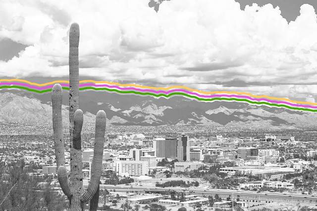
Claiming more than 350 days of sunshine each year, Tucson also boasts mild year-round temperatures and low humidity. The Sonoran Desert surrounding the city provides a spectacular playground for all that sunny weather, beckoning visitors into an otherworldly landscape of cacti, red rocks, and unique desert wildlife. Saguaro National Park and Tucson Mountain Park are excellent ways to experience the best of Tucson’s hiking, mountain biking, and scenic drives. Tucson also has a thriving arts and culture scene with plenty of galleries and museums to check out if all the sun becomes a little too much.
Phoenix sees sun 85% of the time, but all that sunshine comes at a price — the Arizona capital also snags the top spot for hottest city in the U.S. with 107 days of the year seeing temperatures above 100 degrees Fahrenheit. Phoenix may be hot, but for those willing to brave the heat, it has plenty to offer outdoor enthusiasts (and many great options for those who’d rather spend more time inside). Experience the first rays of the day and epic desert views with a sunrise hot air balloon ride or enjoy a sunny afternoon trek up Camelback Mountain, one of the city’s most popular hiking spots. Beat the heat indoors and cool down at a Phoenix Suns NBA game or hit up the Uptown Farmers Market.
Daytime temperatures in Sin City peak from May to September, with averages climbing into the triple digits. Combine this with roughly 3,800 hours of sunshine each year, and it’s clear why rooftop pools and all-day pool parties are a year-round draw. Soak up the sun with a stroll around on the Strip, and duck into one of many heavily air-conditioned casinos when you need to beat the heat. But don’t be shy about venturing Off-Strip: Attractions like the Red Rock National Conservation Area and Sloan Canyon offer fantastic, less-touristed ways to enjoy all the sunny weather Vegas has to offer.
If you’re one who thinks there’s no such thing as too much sun, the northern California city of Redding might be an ideal place to check out in July and August. This northeast California city sees sun 97% of the time in the prime summer months. For the full year, you can depend on sunshine 88% of the time, on average. Although temperatures soar into the high 90s in spring and summer, clear skies and dry weather are ideal for exploring all of Redding’s outdoor attractions — from the 42 waterfalls within a 90-minute drive of the city center to the fascinating subterranean wonders at the Caves of Lake Shasta Caverns National Natural Landmark.
The honor for the sunniest place in the U.S. goes to Yuma, a southwestern Arizona city on the Mexican border. In fact, with 330 days of sun and 4,015 annual hours of sun, Yuma is not only the sunniest place in the U.S. — but also the world. On average, the sun shines here for 90% of the time, and even the darkest month of December sees sun for 82% of daylight hours — making it an optimal place for snowbirds to beat winter blues in many other parts of the United States. Pair the abundant sunshine with outdoor exploration; the 300-foot Imperial Sand Dunes and the ghost town and museum of Castle Dome City are great places to start.
Interesting Facts
Editorial
Interesting Facts writers have been seen in Popular Mechanics, Mental Floss, A+E Networks, and more. They’re fascinated by history, science, food, culture, and the world around them.
Advertisement
top picks from the optimism network
Interesting Facts is part of Optimism, which publishes content that uplifts, informs, and inspires.
As of 2022, there are 7.9 billion people living on Earth — an especially astounding fact when you consider that a little over two centuries ago, the planet crossed the 1 billion mark for the first time. Studying global population trends isn’t just a fascinating endeavor — understanding the growth (or decline) in the Earth’s populations helps researchers to better predict conditions in the future. From the most-populated continent to a municipality with just one person, here are 13 fascinating world population facts that may surprise you.
The Majority of Earth’s Human Population Lives in One Hemisphere
Although the Earth’s hemispheres are equal in geographic size, the Earth’s population is not divided similarly. Roughly 90% of Earth’s human population lives in the Northern Hemisphere, which also accounts for most of the planet’s landmass. The Northern Hemisphere is made up of 39.3% land (the rest is ocean) and also contains many of the world’s most-populated cities, while the Southern Hemisphere only is 19.1% land.
Over Half of the World’s Population Lives on a Single Continent
Earth’s continents are similarly unequal in population distribution — it’s estimated that 60% of Earth’s population (4.7 billion people) lives in Asia. Made up of 48 countries, Asia is also home to the two most populous nations in the world, China and India. China is estimated to currently have 1.44 billion people living in the country, while India is not far behind with an estimated 1.40 billion residents. Together, the two countries account for over half of Asia’s total population.
China and India may be the nations with the highest population, but Japan is home to the most populated city. In 2022, the population of the Tokyo metropolitan area is estimated to be an astounding 37.7 million people, with 13.96 million living in the city itself. To compare, greater Tokyo’s population is almost equivalent to the total sum of the 25 most populated cities in the U.S., which adds up to 37.8 million people. It’s also 1.5 times larger than the next most populous metro area, Seoul.
Monaco Has the World’s Densest Population
Monaco may be the second-smallest country by geographical size, but it does have the world’s densest population. With a population of 39,000 people spread across just three-quarters of a square mile, Monaco has a population density of about 50,000 people per square mile. If you were to consider both independent countries and territories, the Chinese territory of Macau is even more dense, with over 51,000 people per square mile.
Katy, Texas, Has the Most-Populated ZIP Code in the U.S.
California might be the most-populated state in the U.S., but Texas is home to the most populated ZIP code. The Texan ZIP code of 77449 has a population of 128,294 people and belongs to Katy, Texas, a suburb located 30 miles west of Houston. Interestingly, the second most-populated ZIP code in the states also belongs to Katy, with 118,291 residents in the 77494 ZIP code. Five of the top 10 ZIP codes by population are located in the Lone Star State.
Over Half of Indonesia’s Population Lives on a Single Island
Although the archipelago of Indonesia has a total of 17,508 islands, more than half of the nation’s total population resides on the island of Java. Home to the capital city of Jakarta, Java is the most-populated island in the world, with 145 million residents. To put that into context, that’s 17 times more people than all of New York’s five boroughs, which are home to a total of 8.4 million people.
In the lonesome grasslands of Nebraska near the South Dakota border lies the municipality of Monowi. The town’s sole resident is Elsie Eiler, a woman in her 80s who is the town’s mayor, clerk, librarian, and treasurer. As Monowi is an incorporated town for the purposes of the U.S. Census, Eiler receives state funding for municipal road work. However, she has to raise her own funds for the town’s taxes to pay for the street lighting and water.
Nepal’s Population Has the Highest Percentage of Women
Women account for 54.5% of the total population in Nepal, with roughly 2 million more women than men in the South Asian country. One of the primary causes of this high population rate is the country’s life expectancy, with Nepalese women typically outliving Nepalese men. Another reason is the fact that Nepalese men often move abroad for work, while the women usually stay at home.
In the last U.S. Census, Wyoming remained the least populated state in the U.S., with a population of approximately 580,000 residents. The state’s most populous city is Cheyenne, home to about 65,000 people, while the town of Owl Creek has the lowest population with a mere four residents. Housing 5.9 people per square mile, Wyoming is far from congested, especially when compared to California, which has 240.5 people per square mile.
Niger Has the Highest Birth Rate and the Youngest Population
The West African country of Niger has the highest birth rate in the world: Between 2015 and 2020, the average woman in Niger gave birth seven times. Unsurprisingly, this means that Niger has a very young population, with a median age of 15. In fact, with an estimated population of 22.93 million, roughly half of the people who live in Niger are under the age of 14.
In 2050, Earth Will Have 10 Billion Human Inhabitants
In less than 30 years, the world’s population is projected to grow by 2.2 billion people, from 7.8 billion in 2020 to a whopping 10 billion in 2050. This estimation is based on the current global fertility rate, which averages 2.3 births per woman, as well as other population indicators that are tracked in 200 countries around the world. By 2050, many countries in Africa will have doubled their populations, with some countries (such as Angola) expected to increase by a whopping 150%.
The World Is Growing at a Slower Pace Than It Used To
The world population currently grows by an estimated 1.05% to 1.1% per year. However, this is a significant decrease from just 60 years ago, when the world’s annual growth was 2.2% per year. Despite this decline, the world’s population has steadily increased over the past 200 years. Since 1800, the world’s population has increased from 1 billion to 7.9 billion, largely thanks to advances in the medical and agricultural industries.
By 2050, Half of the World’s Population Growth Will Be Concentrated in Nine Countries
While many countries are shrinking in population, others are growing at much faster rates, leading to unequal distribution of global population growth. In fact, just nine countries are predicted to make up more than 50% of population growth by 2050. According to the United Nations, these countries are India, Nigeria, Pakistan, the Democratic Republic of the Congo, Ethiopia, Tanzania, Indonesia, Egypt, and the United States. The same report by the U.N. also revealed that the world’s population continues to grow older, as life expectancy increases across the globe.
Interesting Facts
Editorial
Interesting Facts writers have been seen in Popular Mechanics, Mental Floss, A+E Networks, and more. They’re fascinated by history, science, food, culture, and the world around them.
Advertisement
top picks from the optimism network
Interesting Facts is part of Optimism, which publishes content that uplifts, informs, and inspires.
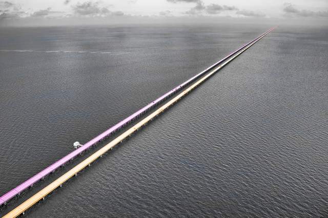
Most of the world’s longest bridges have one thing in common: They’re in Asia, usually China. The Middle Kingdom is responsible for six of the 10 longest bridges in the world, with two in the United States (oddly, both in Louisiana) and one apiece in Thailand and Taiwan. Most of these bridges were also built recently, but several are just over a decade old. Here, for your reading and traversing pleasure, are 10 of the longest bridges in the world.
Should you ever find yourself in the area near Ponchatoula, Louisiana, you may be among the 2,250 drivers who use the Manchac Swamp Bridge on a daily basis. It extends 22.8 miles over a swamp that’s said to be haunted by either a Voodoo princess, a rougarou (Cajun werewolf), or both. Even if you don’t believe in such things, there’s no dismissing the alligators in the water below as mythical creatures.
The Yangtze is the longest river in Asia, flowing 3,915 miles from Tibet’s Tanggula Mountains to the East China Sea. Until 1957, no bridges crossed it and travelers relied on ferries. Now there are many crossings, the longest of which is the 23.48-mile Wuhan Metro Bridge. Part of the city’s elevated Metro line, it opened in 2004.
Better known as the Causeway, this feat of engineering in southeastern Louisiana is recognized by Guinness World Records as the longest continuous bridge over water. Spanning 23.87 miles and completed in 1969, it’s known to cause a feeling of unease: Once you reach the middle, land isn’t visible in either direction and water stretches as far as the eye can see.
Part of the Beijing–Shanghai High-Speed Railway, as are several others on this list, this railway viaduct connects Beijing South and Langfang (located roughly midway between Beijing and Tianjin). The bridge measures 29.8 miles. Construction began in 2010 and was completed the following year.
Until 2008, the Bang Na Expressway — also known as the Burapha Withi Expressway — was the longest bridge in the world, at 33.5 miles long. It held that record for eight years, having been built in 2000, and cost $1 billion to construct. It’s unusual on this list in that it doesn’t cover a body of water, but it does carry a six-lane highway above another highway.
Connecting the cities of Zhengzhou and Xi’an on the Zhengzhou–Xi’an High-Speed Railway, the Weinan Weihe Grand Bridge crosses the Wei, Luofu, Xi, Shi Di, and Ling rivers. It was briefly the longest bridge in the world when it was completed in 2008, but its 49.5 miles were quickly surpassed.
At 70.2 miles long, this railway viaduct spanning from Langfang and Qingxian is also part of the Beijing–Shanghai High-Speed Railway. It was completed in 2010, after four years of construction, and has been used continuously since 2011.
Can you guess which high-speed railway the Cangde Grand Bridge is part of? If you guessed Beijing–Shanghai, you’re right on the money. Said railway runs 819 miles, hence the need for so many proportionally huge bridges. This one comes in at 72 miles long and has 3,092 piers.
A viaduct completed in 2007, the Changhua–Kaohsiung Viaduct is part of the Taiwan High Speed Rail network and is 97.8 miles long. It was built to withstand earthquakes, as this part of Taiwan is known for its seismic activity.
At a whopping 102.4 miles long, the Danyang-Kunshan Grand Bridge is the longest in the world — and probably will be for some time to come. (Do we even need to mention that it’s part of the Beijing–Shanghai High-Speed Railway at this point?) Carrying a price tag of $8.5 billion (or $83 million per mile), it was built to withstand seismic activity, extreme weather, and impact with very large boats (just in case). Constructed over a five-year period between 2006 and 2011, it stands at an average height of 328 feet.
Michael Nordine
Staff Writer
Michael Nordine is a writer and editor living in Denver. A native Angeleno, he has two cats and wishes he had more.
Advertisement
top picks from the optimism network
Interesting Facts is part of Optimism, which publishes content that uplifts, informs, and inspires.
The United States won its independence in 1776, but, of course, Indigenous populations and colonial settlers were here long before then. That means some cities in the nation were founded well before 1776, giving them a long, rich history that predates the country, by centuries in some cases. Here are 10 of the oldest continuously inhabited cities in the United States that you can still visit today.
Weymouth is the second-oldest settlement in Massachusetts, and dates back to 1622. London merchant Thomas Weston sent 60 men there to run a trading post colony to send goods back to England, and named the place Wessagusset. However, the colony was unsuccessful, the settlers soon began to starve, and most opted to move to nearby Plymouth. Six months later, British navy captain Robert Gorges brought 120 men to the Wessagusset site, settled there, and renamed it Weymouth. It became part of the Massachusetts Bay Colony in the 1630s. Located about 10 miles southeast of Boston, the city is now home to approximately 56,000 people.
You’re likely familiar with the story of the pilgrims landing at Plymouth Rock from elementary school classes — but the real history isn’t exactly how many of us have heard it. The pilgrims did arrive there and began to explore their new home in 1620, but it had already been named Plymouth since at least 1614 with Captain John Smith’s journey. There are no actual accounts of the pilgrims landing on the exact spot where Plymouth Rock sits today (you can go see it at the downtown oceanfront), and they had actually likely planned to move on from the spot, but many of the pilgrims were sick and winter was looming. They built their settlement on a former Indigenous cornfield, established their own government under a document called the Mayflower Compact, and operated as an independent province until 1691, when the place was absorbed by Massachusetts.
Credit: Ultima_Gaina/ iStock via Getty Images Plus
Jersey City, New Jersey
The English history of Jersey City, New Jersey — located directly across the Hudson River from New York City — dates back to explorer Henry Hudson and the colony of New Netherland, which was established on Lenape Indigenous land in 1623. Michael Reyniersz Pauw, a knight, was given a land grant in what’s now Jersey City, with the stipulation that he bring in at least 50 people — which he didn’t do. In 1633, he had to sell his land back to the Dutch West India Company. Relations with the Lenape began to falter immediately because of the colonists’ treatment of the Indigenous people, and the settlement was almost completely destroyed within 10 years. The British remained in control of the land until the Revolutionary War. In 1779, Alexander Hamilton joined other leaders from New York and New Jersey to lay out and develop the city. Now, the city is home to nearly 262,000 people — and surrounds the most well-known woman of them all, the Statue of Liberty (though her address is officially in New York).
The English history of Albany, New York, starts with a simple trading post and fort built by the Dutch in 1614 on Iroquois land. Explorer Henry Hudson couldn’t move forward any further on the present-day Hudson River, so his Dutch sponsors opened an administrative outpost for the Dutch West India Company at the point he stopped, on Westerlo Island, called Fort Nassau. Due to ice and flood damage, the fort was moved north in 1615 and then replaced by the new Fort Orange in 1623, a little further north. The Dutch West India Company established a town called Beverwijck in 1652; it became known as Albany (after the Duke of Albany) when the Dutch surrendered to the British in 1664. Albany stayed under British power until the Revolution, and it was named New York’s capital in 1797.
Credit: traveler1116/ iStock via Getty Images Plus
Newport News, Virginia
Although it was officially founded in 1896, Newport News, Virginia, had been a city long before then. It first showed up in print as “Newportes Newes” in the Virginia Company’s 1619 records. Newport News is named after Captain Christopher Newport, who led settlers to Jamestown in 1607. When the colonists left Jamestown in 1610 after a period of starvation, they reunited with Captain Newport on the James River. He told them supplies and reinforcements had arrived, so they returned to Jamestown to await them. From then on, the point at which they met Captain Newport — at the junction of the James River and the Chesapeake Bay — was referred to as Newport’s News. It was eventually shortened to just Newport News. The city now has about 180,000 residents and fans out nearly 70 square miles from that initial meeting point.
Kecoughtan, Virginia, was settled in 1610 by the same English settlers who founded Jamestown. It was originally home to the Kikotan Algonquin tribe and was the place where English settlers first made contact with Virginia’s Indigenous population. While initial meetings were relatively peaceful, the English settlers soon drove away or tragically killed the Indigenous population. By 1690, Kecoughtan was absorbed by the larger city of Hampton, Virginia, and remains a part of its municipality today.
Also founded in 1610, Hampton, Virginia, is the oldest continuously inhabited English-speaking settlement in the country. It is significant because of its military history. After the United States became an independent country, Hampton became a major military outpost due to its strategic location and abundant natural resources. Hampton had easy access to both the Chesapeake Bay and the James River, making it a great port for shipping weapons and other supplies. This also made it an ideal defensive location. During the Civil War, Virginia itself was the capital of the Confederate States. Hampton, however, maintained status as a part of the Union during the entire conflict. Along with Newport News, Norfolk, and Virginia Beach, Hampton is part of the Hampton Roads metropolitan area, home to over 1.8 million people, and celebrates its status as the birthplace of colonial America.
Santa Fe — the oldest state capital still in existence — was officially founded in 1607, but it has actually been in existence since around 1050, when it was home to the Pueblo Native Americans. The Spanish arrived in 1607, and the Pueblo peoples gathered together and attempted to overthrow them toward the end of the 1600s. Their attempts were unsuccessful, and the Spanish took control of the city. Santa Fe remained a Spanish city until 1821, when Mexico declared its independence. Santa Fe was briefly a part of the Texas Republic in 1836, and was eventually conquered from Mexico during the Mexican-American War in 1848, after which it officially became a part of the United States. Santa Fe residents seemingly embrace all aspects of their long and contentious history, and tourists can learn more about it by visiting their fascinating history museums and art galleries.
The second-oldest European-established city in the U.S. is Jamestown, Virginia, founded on April 26, 1607. The first permanent English colony in North America had many ups, downs, and false starts before it became the city it is today. It was originally called “James Fort,” named after James Ⅰ of England, but the settlement was abandoned just three years later after the colonists faced starving conditions and conflict with the Indigenous population. Fourteen years later, however, in 1624, Virginia became an official British colony, and more order was brought to the city, which had slowly been reinhabited. Its name was changed to Jamestown, and the city became the capital of the British colonies. By the mid-19th century, the city was declining, and concerned citizens began campaigns to preserve this original U.S. city in the early 1900s. These efforts were successful, and the city celebrated its 400th year of existence in 2007. Today, you can visit the Jamestown Settlement and see what life was like back in the city’s first years.
St. Augustine, Florida, was founded on September 8, 1565 — more than 200 years before the United States was an official country. Pedro Menéndez de Avilés was an explorer from Spain who came ashore in Florida on August 28, 1565, on the Catholic feast day of St. Augustine. St. Augustine soon became the capital of Spanish-controlled Florida, and remained so until 1824, when the country had been officially united and the capital of Florida became Tallahassee. Today, visitors to the city can discover more about the history of America’s oldest city in the Castillo de San Marcos history museum.
Interesting Facts
Editorial
Interesting Facts writers have been seen in Popular Mechanics, Mental Floss, A+E Networks, and more. They’re fascinated by history, science, food, culture, and the world around them.
Advertisement
top picks from the optimism network
Interesting Facts is part of Optimism, which publishes content that uplifts, informs, and inspires.
The world is as full of wonders as it is wide, and we’ve rounded up some of our most astonishing geography facts to show you just how many wonders there are. From the world’s tallest waterfall being underwater to there being four North Poles, these facts may help you see the globe in a new light — a light possibly even brighter than Las Vegas, the brightest city on Earth. Read on for 25 of our most mind-blowing geography facts from around the website.
The Entire World Population Could Fit Inside Los Angeles
The world population grows larger every year, but we aren’t exactly running out of physical space. In fact, all 7.8 billion of us could easily fit inside Los Angeles. Research has shown that you can fit about 10 people into a square meter, crowded-elevator style; Los Angeles is about 1.2 billion square meters, which means that if we all squeezed together, the city could theoretically fit around 12 billion people. However, we couldn’t do much more than pose for a quick photo before going our separate ways, since there isn’t enough space in L.A. for everyone to actually live in such close quarters.
The moon isn’t as big as it looks. It’s around 27% of the size of Earth and has 14.6 million square miles of surface area. Although this seems like a lot, it’s significantly less than the total surface area of Asia, which is 17.2 million square miles — making Earth’s biggest continent larger than the moon.
Hot spots and geysers represent just a fraction of the action beneath the surface at Yellowstone. The whole park is actually a supervolcano, although it’s not supposed to erupt anytime soon. Yellowstone is actually quite safe. Its supervolcano is made up of two magma chambers; the first is no more than 15% molten, while the second is only 2% molten. According to Forbes, it’s practically impossible for a supervolcano to erupt unless its magma chambers are at least 50% molten. So, rest easy — and don’t forget to enjoy the view.
Nestled between Greenland and Iceland is a body of water known as the Denmark Strait, and beneath its waves lies the world’s largest waterfall. Known simply as the Denmark Strait cataract (a cataract is a type of powerful, flowing waterfall), it cascades 11,500 feet toward the seafloor. This incredible deluge — like other underwater cataracts — is actually a dramatic dance between warm and cold water. In the case of the Denmark Strait cataract, cold water from the Nordic Sea meets the much warmer water of the Irminger Sea southwest of Iceland. The cooler, denser water sinks beneath the lighter, warmer water, dropping more than 2 miles to the seafloor. The resulting waterfall completely dwarfs Venezuela’s Angel Falls, the tallest terrestrial waterfall in the world, by more than 8,000 feet. The Denmark Strait cataract is also a staggering 100 miles wide, nearly 15 times wider than the widest terrestrial waterfall, the Khone Phapheng Falls in Laos, which is only 6.7 miles wide. By every single metric, this underwater avalanche towers over the competition — even though it never rises above sea level.
Istanbul, Turkey, Is Located in Both Europe and Asia
Istanbul (formerly known as Constantinople, and before that as Byzantium) isn’t just the biggest city in Turkey. With 15.4 million people, it’s the most populous city in all of Europe, and its location — between the Black Sea and the Mediterranean — has helped to make it one of the most famous cities in history, not to mention the capital of both the former Byzantine and Ottoman empires. (The capital of modern-day Turkey, incidentally, is the inland city of Ankara.)
In addition to its more than 2,500-year-old history and fascinating architecture (including the Hagia Sophia, built as a church in the sixth century CE), Istanbul is notable for being split between two continents, Europe and Asia, by a thin ribbon of water called the Bosporus. Around one-third of Istanbul’s residents live in Asia — east of the Bosporus — while the rest live in Europe.
At a glance, the universe looks pretty well organized, with perfectly spherical planets orbiting in concentric circles around a glowing orb. But things are a lot more complicated in reality. For example, while our Earth looks like a sphere when viewed from space, it’s actually an irregularly shaped ellipsoid (think a flattened sphere) because of the centrifugal force of its rotation. And its weirdness doesn’t stop there: The precise shape of the Earth is also changing all the time.
The drifting of tectonic plates form entirely new landmasses, and the Earth’s crust is still rebounding from the last ice age 16,000 years ago. While these minute adjustments go mostly unseen, other shape-altering events — such as earthquakes, volcanic eruptions, and asteroid strikes (RIP to our Cretaceous friends) — are hard to miss. But the Earth also changes shape by the hour. Every day (roughly), the Earth experiences two periods of high and low tide, where the gravitational effects of the moon and sun affect the movement of our oceans, and as a result, the shape of the planet, if only temporarily.
There Are Actually Four North Poles in the Arctic Circle
For many, the North Pole is associated with Santa Claus, flying reindeer, and toy-making elves. What most don’t know is that there are actually four recognized North Poles. The Geographical North Pole (aka True North) is the northernmost point on the planet and where all of Earth’s lines of longitude meet. The Magnetic North Pole is the spot at which the planet’s lines of magnetic force all point vertically downward (and the point that attracts the needle of a compass). The Geomagnetic North Pole is the northern end of where the axis of the magnetosphere — the magnetic field that surrounds the Earth and extends into space — intersects the planet. Finally, the North Pole of Inaccessibility is the point in the Arctic Ocean that’s farthest from any coastline.
The thought of a rainforest probably conjures up images of stunning flora and fauna found in the Amazon and other tropical locations. But if you travel to Bosnia and Herzegovina, you will find Perućica, a rainforest and one of two remaining old-growth forests in Europe. The forest lies within Sutjeska National Park and remains protected. Nicknamed “the Lungs of Europe,” Perućica is home to more than 170 species of trees and bushes, including beech, fir, spruce, and mountain maple, as well as more than 1,000 species of herbaceous plants. Visitors especially enjoy the panoramic views from Vidikovac, a lookout point for Skakavac Waterfall, which falls 246 feet into a forest-covered valley.
Thailand used to be called Siam, Ethiopia was once known as Abyssinia, and Australia was initially christened New Holland when Dutch navigators encountered it in the 17th century. The land Down Under received its current English name courtesy of British explorer Matthew Flinders, the first to circumnavigate the continent, who made a hand-drawn map referring to it as Australia a year later in 1804. Britain formally adopted that name for the country in 1824, and by the end of the 1820s it was widely used.
There’s Only One Place in the U.S. Where Four States Meet
Want to try being in four places at once? Then get yourself to the aptly named Four Corners Monument, which marks the intersection of Utah, Colorado, Arizona, and New Mexico. It’s the only place in America where so many states converge, which is especially impressive given that there are 65 spots where three states meet. The exact location of the quadripoint (the technical term for a place where four territories touch) was a matter of more debate than you might expect, with some surveyors arguing that it should have been about 2,000 feet to the west, thanks to changes in the technical reference systems used for various surveys. It wasn’t until a 1925 Supreme Court case that the matter was officially settled.
About 75% of the Earth’s Volcanoes Are Located on the Pacific Ocean’s “Ring of Fire”
About 1,350 potentially active volcanoes dot the Earth today, and the lion’s share of them can be found along a 25,000-mile-long horseshoe-shaped ribbon that borders the Pacific Ocean. This Circum-Pacific Belt, more commonly known as the “Ring of Fire,” is home to some of the most volcanically active areas in the world, including Southeast Asia, New Zealand, Japan, Chile, Alaska, and parts of the contiguous United States. These volcanoes are largely formed at subduction zones, when denser tectonic plates slip underneath lighter plates. This subduction turns the Earth’s dense mantle into magma, which eventually bubbles up as volcanoes.
Only Three Countries in the World Are Entirely Surrounded by One Other Country
A country’s borders can take many shapes and sizes, but only three countries in the world can be considered enclave nations. An enclave is territory of one state surrounded by territory of another, and enclave nations are those that exist wholly within another country’s borders on all sides. In Europe, Italy surrounds two of these enclave nations — Vatican City, the seat of the Roman Catholic Church, and San Marino, a microstate located on the northeastern slopes of the Apennine Mountains. The world’s other enclave nation is Lesotho, a country completely enclosed by South Africa, and which owes at least part of its long history of independent rule to its incredibly mountainous, hard-to-conquer terrain.
Nepal Has One of the Most Unusual Time Zones in the World
Calculating time zones can be a maddening aspect of daily life. In the U.S. alone, 13 states straddle two time zones. Things get even stranger when considering Nepali Standard Time: The landlocked Asian country of Nepal uses a meridian that passes through Gaurishankar, a mountain in the Himalayas, to calculate its time zone. Being 5 hours and 45 minutes ahead of UTC, Nepal is a rare 45-minute deviation, meaning that when it’s noon in Greenwich, England (the basis for UTC), it’s 5:45 p.m. in Nepal. The only other 45-minute deviations in the world are New Zealand’s Chatham Islands and a tiny time zone in western Australia.
Africa Is the Only Continent With Land in All Four Hemispheres
The hemispheres divide the world into four sections, with the equator separating the Northern and Southern hemispheres at zero degrees latitude and the prime meridian separating the Western and Eastern hemispheres at zero degrees longitude. Most continents fall within only a few of these invisible boundaries, but one has land in all four hemispheres: Africa. The equator passes through seven African nations (the Democratic Republic of the Congo, Gabon, Kenya, Republic of Congo, São Tomé and Príncipe, Somalia, and Uganda), while the prime meridian crosses five (Algeria, Burkina Faso, Ghana, Mali, and Tongo). With 12 hemisphere-spanning countries and land at both the prime meridian and equator, Africa’s spot on the map is unparalleled.
The Westernmost and Easternmost Points of U.S. Territory Share the Same Name
The shape of the United States has changed over the centuries — including its farthest reaches east and west. Today, the lower 48 states stretch around 3,000 miles, but the true span of the United States has more than tripled thanks to some of the country’s island acquisitions. In the east, the farthest point in the U.S. in relation to the mainland is Point Udall, located on the island of St. Croix in the Caribbean. Strangely, the farthest point to the west — on the remote Pacific island of Guam — is also called Point Udall. Although the namesakes honor two different men, they do honor the same family. Point Udall in St. Croix is named after Stewart Udall, who served as secretary of the interior for Presidents John F. Kennedy and Lyndon B. Johnson. Guam’s Point Udall is named for Stewart’s brother, Morris, who served as a U.S. congressman from Arizona from 1961 to 1991.
Glasgow, Montana, Is the Most Isolated Town in the Contiguous U.S.
The American West is known for its wide open spaces, but nowhere is quite as wide open as the area around Glasgow, Montana. Crunching some numbers back in 2018 in an effort to definitively define “the middle of nowhere,” The Washington Post found that a whopping 98% of Americans in the contiguous U.S. live within an hour of some kind of urban center (that is, a metropolitan area with at least 75,000 people). But Glasgow, located in the northeast corner of the state, is an estimated 4.5 hours from the nearest urban center, making it the most isolated town (with a population of 1,000 or more) in the Lower 48.
About 80% of the world’s population lives in a place lit up by artificial light at night. And according to NASA, nowhere do those lights shine brighter than in Las Vegas. A city that loves its neon signs and bright marquees, Las Vegas offers an around-the-clock dose of sensory overload — even New York City, “the city that never sleeps,” and Paris, “the city of lights,” can’t match the over-the-top light show of Las Vegas when viewed from outer space. And in a city with so much artificial light, one manages to stand out: the Sky Beam atop the Luxor Hotel pyramid. It’s powered by 39 ultra-bright xenon lamps (each 7,000 watts) and curved mirrors that collect their light and focus them into the world’s strongest beam of light. Not only can it be seen from space, but the Sky Beam provides enough illumination to read a book from 10 miles out in space.
In the second half of the 19th century, Chicago was one of the fastest-growing cities in the world. But along with that population boom came unfortunate side effects, including waterborne diseases such as cholera and typhoid. The problem was in large part that the city’s sewage flowed into the Chicago River, which in turn emptied into Lake Michigan — the source of the city’s drinking water. So Chicago turned to engineer Ellis S. Chesbrough, designer of the city’s sewer system, to solve the problem once and for all.
Chesbrough concluded that if the city’s eponymous river could just flow away from Lake Michigan and empty into the waterways leading to the Mississippi, Chicago’s water problems would be over. The subcontinental divide just west of Chicago is what caused the river to flow toward the lake, so if the city dug a ditch lower than both the lake and the river through the divide, gravity would take it from there. Workers began the laborious process of reversing the Chicago River in 1892, and after eight years of digging, Chicago blew up the last dam on January 2, 1900, reversing the river’s flow. This ambitious plan ended up saving the city, securing its prosperous future into the 20th century and beyond.
The Position of the Arctic Circle Changes Every Year
The Arctic Circle is located at approximately 66.3 degrees north of the equator; however, its actual location changes slightly every year. This is due to the fluctuation of Earth’s axial tilt, which is influenced by the orbit of the moon and the consequent tidal changes. The same axial tilt causes the different seasons that we experience on Earth. Currently, the circle is moving north at a rate of around 49 feet per year. In 2017, an art exhibit called Orbis et Globus was inaugurated on Iceland’s Grimsey Island to monitor the circle’s movements.
100 Lightning Bolts Strike Earth Every Second on Average
The Earth’s atmosphere is filled with electricity. Every second, 100 cloud-to-ground lightning strikes hit the Earth. Considering that most lightning only takes place in clouds and never hits the ground, that makes Earth quite an electrifying place. Lightning happens because air in clouds acts as an insulator between positive and negative charges that exist within clouds and between clouds and the ground. When these opposite charges build up enough, the air can no longer insulate and breaks down — a phenomenon we experience as lightning. To add even more drama, lightning traveling at 200,000,000 mph superheats the surrounding air to 50,000 degrees Fahrenheit — that’s nearly five times hotter than the surface of the sun — but only for a fraction of a second. This intense heat causes air to expand and vibrate, creating thunder. But while lightning is indeed common, only one out of every 5,000 Americans will be struck by it during their lifetime.
The Grand Canyon Isn’t the Deepest Canyon in the U.S.
Given its name, it’s a common misconception that the Grand Canyon is the deepest canyon in the United States. The Grand Canyon is very deep — 4,000 feet deep, in fact, with the deepest point reaching 6,000 feet. This gives it an average depth of about a mile. But Hells Canyon, running along the border of Oregon and Idaho, exceeds the depth of the Grand Canyon by plunging nearly 8,000 feet in some places.
Only 19% of the Ocean’s Floor Has Been Mapped in Detail
Despite covering most of the Earth, much of the ocean has yet to be explored — or even mapped. A 2014 seafloor map developed by an international team of researchers revealed every oceanic feature larger than about 3 miles across, which means we have a strong sense of underwater mountains, but smaller objects — like centuries-old shipwrecks — continue to elude us.
The Nippon Foundation-GEBCO Seabed 2030 Project hopes to survey the entire ocean floor in detail within the next nine years. As of 2020, they estimated that 19% of the seafloor had been mapped in detail. They’re working quickly: When the project began in 2017, only 6% of the seafloor was mapped in detail. Yet they still have an area roughly twice the size of Mars to cover.
The Earth’s Surface Is “Recycled” Every 500 Million Years
Approximately every 27 days, humans replace their skin. The Earth undergoes a similar process — it just takes 500 million years. As tectonic plates ram into each other, creating what’s called subduction zones (the Ring of Fire volcanic chain, for example, is a series of subduction zones bordering the Pacific Plate), the plates dip below lighter continental plates. The subducted rock is heated into magma and becomes future lava plumes forming new landmasses. Scientists used to believe that this process took nearly 2 billion years to complete, but new analysis of basaltic lava on Mauna Loa volcano in Hawaii proves that Earth recycles its “skin” in about a quarter of that time, or every 500 million years.
In Nova Scotia, You Can Stand on the Corner of “This Street” and “That Street”
Drive down the highway in Nova Scotia, Canada, some 30 minutes northeast of Halifax, and you’ll run into a trio of odd street names. Just down the street from the Porters Lake Community Center, at the tip of a peninsula jutting out into nearby Porters Lake, are This Street, That Street, and The Other Street, referencing the idiom “this, that, and the other.” Strange as these street names may seem, the 3,200 or so residents of Porters Lake would find common ground with Americans in Culver, Oregon, who named two of their streets “This Way Lane” and “That Way Lane.” (Meanwhile, in a somewhat similar vein, attendees of the Tennessee music festival Bonnaroo have to Abbott & Costello their way around What Stage, Which Stage, This Tent, That Tent, and The Other Tent.)
Standing 29,032 feet above sea level in between Nepal and Tibet, Mount Everest is the world’s highest peak. It’s also still growing. While there’s a push-pull dynamic at work in its vertical expansion — plate tectonics push it further into the sky at the same time that erosion does the opposite — the mountain gets about 4 millimeters (0.16 inches) taller per year on average. That means it’s actually growing at a slightly slower rate than many of its Himalayan counterparts, some of which are rising about 10 millimeters (0.4 inches) each year.
Feature image credit:Original photo by Vixit/ Shutterstock
Interesting Facts
Editorial
Interesting Facts writers have been seen in Popular Mechanics, Mental Floss, A+E Networks, and more. They’re fascinated by history, science, food, culture, and the world around them.
Advertisement
top picks from the optimism network
Interesting Facts is part of Optimism, which publishes content that uplifts, informs, and inspires.
What’s the world’s biggest airport? What about the busiest? Why is there an “X” in PDX? Is there a way to get a nap between flights? And what happens to all the change you leave in airport security bins?
Airports are big, crowded, and full of questions. The following 15 facts might change the way you catch your next flight — or at least end some mysteries.
The World’s Largest Airport Is the Size of New York City
King Fahd International Airport near Dammam, Saudi Arabia, has a larger area than any other airport. It’s 780 square kilometers, or about 300 square miles. That’s almost exactly the same size as New York City — yes, all five boroughs. As Guinness World Records points out, it’s larger than the entire neighboring country of Bahrain, which has three airports of its own.
Hartsfield–Jackson Atlanta International Airport in Atlanta, Georgia, is the busiest airport in the world for passengers, serving 93,699,630 people in 2022 — and aside from a brief blip in 2020, it has held the No. 1 spot since 1998. It’s not even close: The next-busiest airport for passengers, Dallas/Fort Worth International Airport, was more than 20 million people behind in 2022.
So why is it so popular? First, there aren’t a lot of other international airports in the immediate area, so it’s the closest international airport for much of the South. It’s also Delta Air Lines’ biggest hub. It makes a lot of sense for transfers, too. According to the airport, it’s within a two-hour flight of around 80% of the population of the United States — and unlike the major metropolitan areas that you’d maybe expect to be the busiest, it doesn’t have to deal with traffic from other nearby airports.
Celebrities do fly commercial, even if they’re flying first class, so why do you never see them sweating in the boarding line with everyone else? Many airports have private or exclusive terminals for the rich and/or famous. LAX (Los Angeles) and ATL (Atlanta) have The Private Suite, which provides comfy accommodations, valet parking, and, as the name suggests, private suites to hang out in while waiting for departure. It even has dedicated customs and security on-site. It’ll cost you, though: Memberships start at $1,250 a year, and that doesn’t even come with a discount for the $4,850 price tag on a preflight suite. It will get you free massages and manicures while you wait, though.
Airlines Pad Flight Times to Make Planes Look More Punctual
On paper, flights take a lot longer than they used to, even though the airports are located in the same place and the planes haven’t gotten slower. It’s because airlines have started building in some extra wiggle room, so that a plane has a better chance of landing at its destination on time, even if it has a delayed departure. Despite this, around 30% of planes still arrive more than 15 minutes after their scheduled arrival time.
The World’s Tallest Air Traffic Control Tower Is in Saudi Arabia
Perhaps fittingly for the nation with the world’s largest airport (see above), the world’s tallest air traffic control tower is also located in Saudi Arabia. The tower at Jeddah King Abdulaziz International Airport in Saudi Arabia stands at 136 meters (446 feet), and surpassed the next-tallest tower, at Kuala Lumpur International Airport in Malaysia, in 2017. The tower in Saudi Arabia is about as tall as the Great Pyramid of Giza.
Amsterdam Airport Schiphol has all sorts of quirky, cozy amenities, including a library, an art gallery, and three-dimensional cow tiles, but Airport Park blows them all away. The green oasis opened in 2011, and while the vast majority of the plants are fake, it’s built around the very real trunk of a 130-year-old copper beech tree. To give the illusion of the outdoors, the airport pipes in parklike sounds such as birdsong. Visitors can even hop on a bike that also charges their phone. For a real breath of fresh air, there’s a small outdoor terrace.
The “X” and the end of “PHX” makes sense for Phoenix Sky Harbor International Airport — but what about “LAX” for Los Angeles and “PDX” for Portland?
Turns out, the “X” is left over from the days when airports used two-letter codes from the National Weather Service. With the rapid growth of air travel, it soon became apparent that two letters wouldn’t be enough. When International Air Transport Association (IATA) three-letter codes became the norm in the 1930s, some airports gained an “X” at the end.
Then there’s Sioux City Gateway Airport, which is blessed with the IATA code “SUX.” In 1988 and 2002, officials petitioned to change the code, and were offered five options by the FAA: GWU, GYO, GYT, SGV, and GAY. They opted to embrace what they already had instead, and introduced a line of merchandise — beanies, mugs, and more — emblazoned with the “SUX” logo.
The Wright Brothers’ Airport Is the World’s Oldest Continuously Operating Airport
Flight pioneer Wilbur Wright established College Park Airport in College Park, Maryland, in 1909 as a training ground for two military officers as they got ready to fly the government’s first airplane. More than a century later, it’s still a public airport, making it the oldest continuously operating airport in the world.
There’s a little bit of an asterisk on that record, though, in that you can’t really catch a flight there — unless you have or know somebody with an aircraft and a pilot’s license. Which brings us to…
Hamburg Airport Is the Oldest Continuously Operating Commercial Airport
If you’re looking for the oldest airport with terminals and plane tickets, look no further than Hamburg Airport, established in 1911. But while America was building its aviation history on airplanes, Germany built the facility around the country’s own technology: Zeppelins.
Count Ferdinand von Zeppelin, the inventor of the Zeppelin airship in the 1890s, gave an enthusiastic speech about the future of air travel in Hamburg in 1910. Residents believed in his vision, and the first building at the Hamburg Airport was an airship hangar, built in 1912. However, it took less than a decade for airplanes to start taking over. The airport broke the one-million passenger mark in 1961.
Airlines Pay Up to Eight Figures for Slots on the Airport’s Schedule
To keep air traffic running smoothly and safely in more than 200 of the world’s busiest airports, airport operators grant airlines slots that give them authorization to take off or land at certain times — and in many places, demand is far outpacing supply.
The most expensive slots are at Heathrow International Airport in London, England. In 2016, Kenya Airways sold its only slot to Oman Air for a whopping $75 million. That’s on the high side, but eight figures is relatively common. One year later, two slots fetched the same price when Scandinavian Airlines decided to sell.
Because an airline can lose that valuable asset if it doesn’t use it at least 80% of the time in a six-month period, you might see some unusual scheduling. At one point, British Mediterranean Airways was operating round-trip flights between Heathrow and Cardiff Airport in Rhoose, Wales — a journey of just a few hours by car or train — with zero passengers, angering environmental activists (among others). And with demand for air travel having decreased during the ongoing COVID-19 pandemic, some airlines aren’t canceling their underbooked flights, leading to more empty planes journeying through the skies.
Ever wonder where your favorite nail clippers and corkscrews went after airport security confiscated them? In some states, they end up in government auctions — and they sell in bulk.
Lost luggage is also sold if it’s not picked up within three months, but the process is a little more streamlined. A reseller called Unclaimed Baggage sorts through and resells, repurposes, or recycles the bags and their contents. Speaking of airport security …
With hundreds of thousands of travelers throwing wallets into bins every day, some loose change is bound to fall out and get left behind. Over time, that really adds up; in 2020 alone, the Transit Security Administration (TSA) gathered more than $500,000 in loose change, and that’s during a pandemic — in 2019, they picked up more than $900,000. The biggest source of lost change was Harry Reid (formerly McCarran) International Airport near Las Vegas, where passengers left behind $37,611.61.
The TSA has to submit reports to Congress every year on how much they’ve gathered and what they spent it on. They ended 2020 with $1.5 million, including money leftover from previous years, and spent much of it on pandemic mitigation measures like masks, gloves, and face shields.
During a longer layover or delay, travelers sometimes stay at nearby hotels, then head back through security to catch their next flight. But if you just need a quick nap or a moment of quiet — or you’re worried about oversleeping — transit hotels are located literally inside the airport.
Aerotel has locations throughout Asia (and a few outside) for some sleep and a shower between, before, or after flights, whether you need an hour-long nap or an overnight stay. Yotel, with airport locations in Amsterdam, London, Istanbul, Paris, and Singapore, fills a similar niche: You can book as little as four hours in a relatively barebones room, with a bed or two, shower, and Wi-Fi.
More traditional hotels built for regular sleeping also exist inside airports, but often offer shorter-term options designed for decompressing during a layover — you just might pay a little extra for the bells and whistles. The Hilton Munich Airport offers a two-hour spa card, and Grand Hyatt DFW and JFK’s midcentury-themed TWA Hotel both offer fixed day-use rates that include access to the pool (starting at $109 in Dallas and around $149 at TWA).
Anxious before your flight? Need a little dog cuddle? As of August 2021, dozens of airports in North America had some kind of therapy dog program, whether it was daily dog visitors or a once-a-month treat. One of the biggest operations is the Pets Unstressing Passengers (PUP) program in Los Angeles International Airport (LAX), which had around 121 dogs participating before the pandemic — most of them rescue dogs, and all of them with appropriate certifications and on-the-job experience. Each dog has a handsome red vest and weekly shift of 1-2 hours, and handlers double as customer service reps that can help you find your way to the correct gate.
Each therapy dog program is as special as its four-legged volunteers. Fort Lauderdale-Hollywood International Airport (FLL) in Broward County, Florida, has eight “FLL AmbassaDogs” that include a Yorkshire Terrier named Tiffany who rides around in a stroller. At the Edmonton International Airport in Alberta, Canada, pups and handlers wear matching outfits and distribute trading cards. In 2016, the San Francisco International Airport (SFO) added a Juliana pig named LiLou to its “Wag Brigade.”
Interesting Facts
Editorial
Interesting Facts writers have been seen in Popular Mechanics, Mental Floss, A+E Networks, and more. They’re fascinated by history, science, food, culture, and the world around them.
Advertisement
top picks from the optimism network
Interesting Facts is part of Optimism, which publishes content that uplifts, informs, and inspires.
The many borders that criss-cross our world often neatly separate the planet into countries, states, territories, counties, cities, and towns. But sometimes, thanks to a variety of historical and geographic factors, the world’s borders aren’t so clear-cut. Here are 10 surprising and often bizarre borders around the world you may not have heard about — from ones that run straight through towns and businesses to an island that changes hands every six months.
In Derby Line, Vermont, the U.S.-Canada Border Runs Right Through Town
On one side of the street, you’re in Derby Line, Vermont. On the other side, you’re in Stanstead, Quebec. The border between the U.S. and Canada goes right through these two towns (which basically function as one), through businesses and along a main street named Canusa Avenue. In one area, the border is even made up of flower pots. No one knows exactly why the border was sent straight through town in the early 1700s (some attribute it to a simple mapmaking error), but Derby Line-Stanstead has chosen to embrace it. The curling hall is in both countries, and so is the library. There is a customs house and border patrol, however, so if you’re out crossing the road, you’ll need to show a passport.
Though it may appear on a map that Bosnia is landlocked, a closer look reveals that the country has a narrow strip of land that extends through Croatia and gives the country just 12 miles of shoreline on the Adriatic Sea. Called the Neum Corridor, the border dates to the 1699 Treaty of Karlowitz, which gave a substantial amount of land around the Croatian city of Dubrovnik to Venice, Italy. Dubrovnik was worried about being so close to Venice and the potential for invasion, so they gave away some of their land to the Ottomans as a buffer — and since Bosnia and Herzegovina were Ottoman-ruled provinces, that’s where the Neum Corridor is today. Aside from Monaco, Bosnia has the shortest coastline of any other country thanks to this stretch of land.
The France-Switzerland Border Goes Through a Hotel
Guests at the Hotel L’Arbézie Franco-Suisse have the unique opportunity to sleep in two countries at once. The hotel sits right on the border between France and Switzerland in the alpine village of La Cure, 15 miles northwest of Lake Geneva. It was built between 1862 and 1863, when Napoleon III redrew the border between the two countries — right through the land owned by a French citizen named Ponthus Arbez, who decided to build a house on the border before it became official. At first, the French side had a bar and the Swiss side had a store, but when Arbez died, his sons converted the property into a hotel in 1921. Today, guests can cross between the international border in the hotel’s dining room, and some rooms even allow them to sleep with their heads in France and their feet in Switzerland.
Belgium and the Netherlands Have Borders Within Borders
The border between Baarle-Nassau, a town in the southern Netherlands, and Baarle-Hertog, Belgium, is one of the most complicated borders in the world. The border zigzags through the Dutch town and creates a series of Belgian enclaves — parcels of land that belong to Belgium but are completely surrounded by the Netherlands. However, some of those Belgian enclaves themselves contain Dutch enclaves, like a border-based version of Inception. The border goes through homes, businesses, parks, and probably even a couch or two. It’s marked along the ground with a series of white crosses. The peculiar arrangement was a result of medieval land treaties and swaps, when landlines were determined by the aristocrats that lived there.
The Highest Border in the World Is Atop Mount Everest
Mount Everest is the world’s tallest mountain, and since it straddles the border between China and Nepal, it’s also home to the world’s highest border. The border goes right through the summit, and climbers can scale the mountain from both sides. And in 2020, the world’s most elevated border got even higher. China and Nepal separately took new measurements of the summit and then jointly announced that Mount Everest was even taller than they had originally thought. Now, Mount Everest’s apex is officially 29,032 feet — just about three feet taller than before.
Northwest Angle, Minnesota, Is Surrounded by Canada, a Lake, and a Video Phone Booth
If you want to visit Northwest Angle in Minnesota, you either have to travel through Canada or take a boat or float plane to get there. The small community of about 120 people is the only part of the contiguous United States that extends north of the 49th parallel. The Angle, as it’s known by locals, borders the Canadian provinces of Manitoba and Ontario and is separated from the rest of Minnesota by the Lake of the Woods. Northwest Angle is the result of a mapmaking error, when early explorers misattributed the source of the Mississippi River. Since the area is so remote, if you want to use the land border to cross into Canada and continue back into Northwest Angle, Minnesota, you have to go into a booth to place a video call to Canadian or American customs officers to pass through.
A Tiny Island Changes Hands Between France and Spain Every Six Months
The border of Pheasant Island, located in the Bidasoa River between southwestern France and northeastern Spain, has changed more than 700 times. There are no permanent residents on the two-acre island and visitors are banned — except for twice a year, when government representatives from each country come together on the island to transfer ownership. The island is considered to be a symbol of peace and neutrality. After the Thirty Years War ended in 1648, France and Spain signed the Treaty of the Pyrenees on the island and made sure it would alternate ownership in perpetuity to demonstrate equality between the two nations. Pheasant Island is what’s known as a condominium, a territory belonging to two separate nations at the same time.
With no permanent residents and no one looking to claim it, Bir Tawil is a true no-man’s land — one of the last unclaimed areas on Earth. The trapezoid-shaped, almost entirely barren land is located north of Sudan and south of Egypt. But neither Egypt nor Sudan want to claim the land as their own because of a border technicality. Neighboring Hala’ib is much more valuable land to both countries because it abuts the Red Sea, but when British colonists drew border lines, the agreement stipulated that each country can only have one of the territories and not both. If they claim Bir Tawil, they’ll lose lucrative Hala’ib, which is still disputed between Egypt and Sudan.
The Island of Tasmania Actually Has One Land Border
Tasmania is a 26,000-square-mile island located about 150 miles south of mainland Australia. The island makes up one of Australia’s six states and territories, but it shares a small border with another Australian state: Victoria. Located on a small island called Boundary Islet, the border is only 279 feet long and was created by accident. Back in 1825 when the Tasmania-Victoria border was drawn in Australia, no one noticed the tiny island, so the border ended up running right through it. Boundary Islet has no human residents — just New Zealand fur seals and crested terns.
The Kingdom of Talossa’s Borders Are in Milwaukee, Wisconsin
It’s not an internationally recognized border, but it’s a border nonetheless: The Kingdom of Talossa is a sovereign microstate (at least to its citizens) that sits right in downtown Milwaukee, bordered by Lake Michigan on its eastern side. Talossa has its own language, its own government, its own flag, and its own discussion forums for anybody who wants to become a citizen. The micronation was founded in 1979 when a 14-year-old boy named Robert Ben Madison who was confined to his room decided to secede from the United States and create a constitutional monarchy. Although it wasn’t taken seriously at first, by the time the internet rolled around, the Kingdom of Talossa went viral and captured the imagination of many others, who joined in as citizens.
Interesting Facts
Editorial
Interesting Facts writers have been seen in Popular Mechanics, Mental Floss, A+E Networks, and more. They’re fascinated by history, science, food, culture, and the world around them.
Advertisement
top picks from the optimism network
Interesting Facts is part of Optimism, which publishes content that uplifts, informs, and inspires.
Think you know all there is to know about the world’s most-visited sites? One lesson that savvy travelers learn is that even the most well-known landmarks — the ones that clutter our Instagram feeds and continue to attract millions of tourists each year — can still surprise you. If you’re curious about what purpose Times Square originally served, what other famous landmark Gustave Eiffel helped design, or what color the pyramids of Giza once were, read on to discover 15 things you never knew about 15 of the top tourist attractions on the planet.
New York City’s Times Square Wasn’t Always Called That
For the most-visited tourist site in the U.S., New York City’s Times Square had humble beginnings. Once an area surrounded by countryside and used for farming by American Revolution-era statesman John Morin Scott, the area now known as Times Square fell into the hands of real estate mogul John Jacob Astor in the 1800s. By the second half of the 19th century, it had become the center of the city’s horse carriage manufacturing industry and home to William H. Vanderbilt’s American Horse Exchange. City authorities named it Long Acre Square, a reference to London’s historic carriage and coach-making district. This name remained until 1904, when The New York Times moved its headquarters to a lavish new skyscraper called One Times Square. Just eight years later, the newspaper relocated again to a nearby building, but the name Times Square stuck.
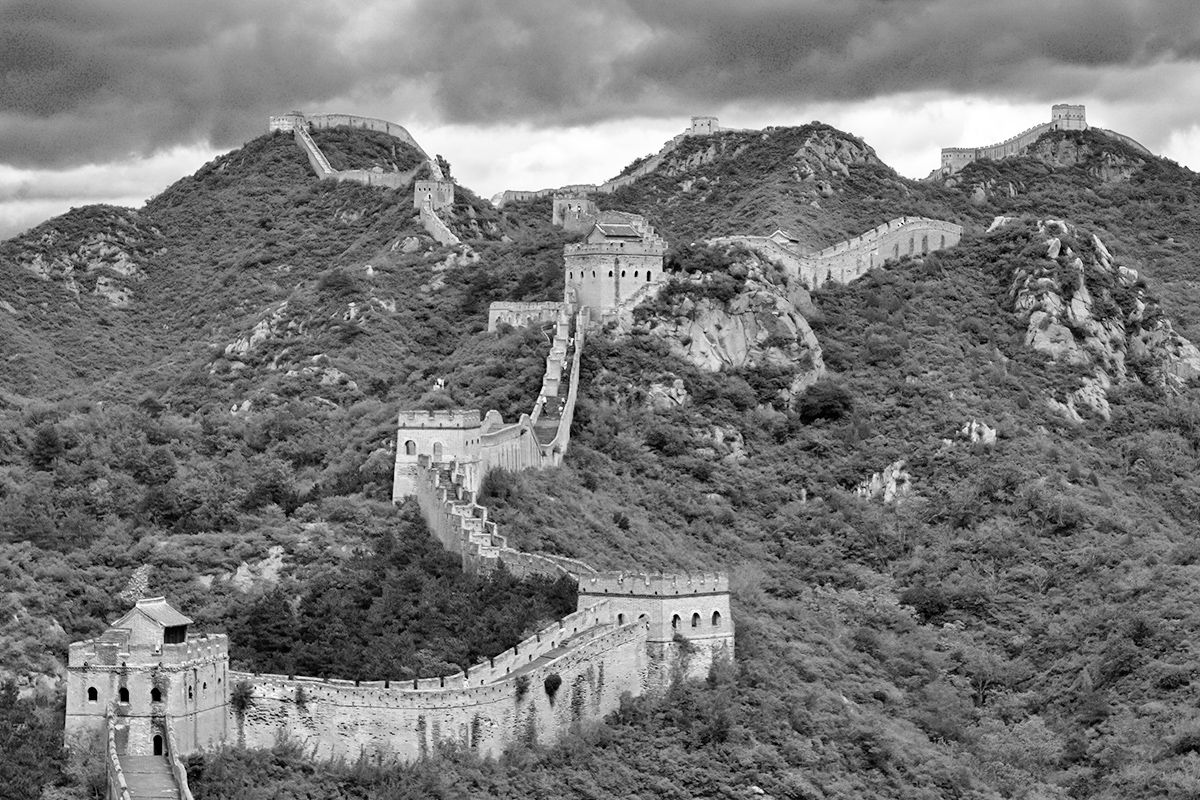
The Great Wall of China Isn’t a Continuous Structure
Built from the third century BCE to the 17th century CE in order to keep out northern invaders, the Great Wall of China is considered the world’s longest wall, extending a total 13,170 miles. Although our mental image of the Great Wall is probably one of a continuous structure winding its way across China, the reality is different. The Great Wall is actually composed of various stretches of wall and watchtowers — often with gaps between. There are even areas where the wall is non-existent. The original builders also made use of natural barriers to keep invaders out. As much as a quarter of the wall’s length relied on features like rivers and mountainous ridges to keep the marauding hordes back. Today, much of the wall is in ruins, but sections that date from the Ming Dynasty (1368–1644) can still be seen.
Las Vegas Is the Brightest City on Earth
About 80% of the world’s population lives in a place lit up by artificial light at night. And according to NASA, nowhere do those lights shine brighter than in Las Vegas. A city that loves its neon signs and bright marquees, Las Vegas offers an around-the-clock dose of sensory overload — even New York City, “the city that never sleeps,” and Paris, “the city of lights” can’t match the over-the-top light show of Las Vegas when viewed from outer space. And in a city with so much artificial light, one manages to stand out: the Sky Beam atop the Luxor Hotel pyramid. It’s powered by 39 ultra-bright xenon lamps (each 7,000 watts) and curved mirrors that collect their light and focus them into the world’s strongest beam of light. Not only can it be seen from space, but the Sky Beam provides enough illumination to read a book from 10 miles out in space.
Credit: Freddy G/ Unsplash
Gustave Eiffel Helped Designed the Statue of Liberty
Even prior to the building of his namesake tower in Paris, Alexandre-Gustave Eiffel was already one of France’s leading structural engineers in the 19th century. Thus, he was a natural choice for New York Harbor’s Statue of Liberty, especially after the statue’s original designer died unexpectedly. Thanks to Eiffel, the statue’s interior boasts a more contemporary design. Eiffel came up with the idea of a central spine in the statue, which functions as a connector for the various asymmetrical metal girders that give the statue its shape. This innovative technique not only provides the framework for the statue but also creates a kind of suspension system that allows the monument to withstand winds and other harsh weather conditions.
The Great Barrier Reef Is So Large You Can See It From Space
Australia’s Great Barrier Reef is the largest coral reef ecosystem on the planet, covering an area of approximately 135,000 square miles. It’s not just the immense scale of the reef that makes it visible to astronauts in space, though. The contrast between the dark blue of the deeper parts of the ocean and the light turquoise of the lagoons on the other side of the reef makes it relatively straightforward to identify with the naked eye. But the pictures taken from space are valued for more than their aesthetic appeal. The MERIS sensor used on the Envisat satellite mission was a useful tool in mapping the extent of coral bleaching, the term for when stressed coral has rid itself of algae.
The Grand Canyon Isn’t the Deepest Canyon in the U.S.
Given its name, it’s a common misconception that the Grand Canyon is the deepest canyon in the United States. The Grand Canyon is very deep — 4,000 feet deep, in fact, with the deepest point reaching 6,000 feet. This gives it an average depth of about a mile. But Hells Canyon, running along the border of Oregon and Idaho, exceeds the depth of the Grand Canyon by plunging nearly 8,000 feet in some places. While not the country’s deepest canyon, the Arizona landmark has other impressive stats: It extends for 277 miles and measures 18 miles wide. Totaling 1,904 square miles, this canyon is roughly the size of Rhode Island. And the national park there is visited by around 6 million people each year.
We Know of the “Lost” City of Petra, Jordan, Thanks to a Swiss Explorer
Once a thriving cultural and economic hub, Petra (believed to have been established around 312 BCE) was later abandoned and left to ruin. For centuries, all except the local Bedouin people forgot Petra — its tombs and temples carved directly into the sandstone cliffs were abandoned and buildings fell into ruin, hidden by the surrounding canyons. But in 1812, a Swiss explorer named Johann Ludwig Burckhardt set off on an expedition in search of the source of the River Niger. On his way to Cairo, he heard rumors from locals of secret ruins of a grand city in the desert, so he hired guides and disguised himself as an Arab to gain access to what was considered a sacred place, forbidden to Westerners. They brought him to Petra. However, wary of pushing his luck too far, he didn’t stop to excavate. Five years later, Burckhardt died of dysentery in the Egyptian capital, but his “discovery” paved the way for future exploration of the site.
The Golden Gate Bridge’s Color Was Supposed To Be Temporary
San Francisco’s Golden Gate Bridge features a distinctive reddish-orange paint color — but it came about by accident. Architect Irving Morrow noticed that some of the steel that arrived for construction of the bridge was coated in a dark red primer, which inspired him to write a 29-page report in 1935 advocating for a similar color to be used in the bridge’s final design. Although most bridges at the time were painted gray, silver, or black, he suggested using paint in a shade like orange vermillion or burnt sienna, as these luminous tones would emphasize the grand scale of the bridge and provide a contrast to the grey and blue color of the water beneath. Not everyone agreed, but in the end, Morrow won over his critics. The bridge was painted a shade unimaginatively called “International Orange,” and it’s been the same ever since.
Machu Picchu’s Buildings Were Designed To Be Earthquake-Proof
The Inca people certainly knew how to build to accommodate their environment. That’s evident not only in Machu Picchu’s epic surroundings, but also in the foundation of the Lost City itself. Peru is located in a seismic zone, and the Incas were familiar with potential earthquakes. To protect against them, they made the buildings of the citadel seismic-resistant by using precisely fit stones held together by gravity alone. Nothing so thin as a credit card could be inserted in the cracks, allowing the mortar-free stones to “dance” during an earthquake, only to resettle back into place once it ends. Additionally, the Incas cornered structures with L-shaped blocks, built terrace buttresses into steep mountain slopes, rounded the corners in some buildings, and tilted the trapezoidal doors and windows inward. All of these small but ingenious details ensured that their structures were earthquake-ready.
There’s a Secret Suite Inside Disney World’s Cinderella Castle
Cinderella’s castle at Walt Disney World in Orlando, Florida, holds a few secrets. For starters, the bricks used to build the tops of the tall towers are smaller than the bricks used for the lower part of the structure — an engineering trick used by the designers in many buildings here to make them appear even taller than they truly are. Perhaps even more surprising, there’s a hidden suite inside this castle that was originally designed to be an office for Walt Disney himself, but he died before the castle was completed. Cinderella’s castle isn’t the only one hiding a surprise: Sleeping Beauty’s resting place (at Disneyland in California) boasts an actual working drawbridge. Reportedly, it has been used just twice, once for the opening ceremony in 1955 and again in the 1980s when Fantasyland opened.
The Taj Mahal’s Four Minarets Look Perpendicular — But They’re Not
In the 1600s, Mughal emperor Shah Jahan built India’s Taj Mahal to honor the memory of his third wife, Mumtaz Mahal. Four 130-foot-tall minarets surround the Taj Mahal’s central tomb, where Shah Jahan and his wife are both buried, and showcase the emperor’s passion for symmetrical design. At first glance, they seem to stand perfectly perpendicular to the ground; however, on closer inspection you’ll notice they are tilted slightly outwards. This wasn’t a design fault, but rather a way to protect the tomb in the event of a natural disaster — should the minarets fall, then the material would land away from the building. The four towers were built to be used by a muezzin, the person who calls daily prayers, and each features two balconies and an elevated dome-shaped pavilion, called a chattri.
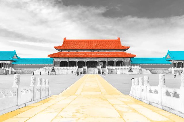
Beijing’s Forbidden City Is the World’s Largest Imperial Palace
Occupying some 7.7 million square feet, the Forbidden City is the largest imperial palace on the planet. The most-visited UNESCO World Heritage Site in the world, it features 980 individual buildings, which are home to almost 9,000 rooms. There are two distinct areas: The Inner Court served as the emperor’s residence, while the Outer Court was for ceremonial events. A 32-feet-high defensive wall protects the entire complex, around which is a 171-foot-wide moat. What’s inside is even more impressive: The palace is home to a reputed 1.9 million artifacts — everything from calligraphy, ceramics, and paintings to gold and silverware, literary works, and religious icons.
Some of the Stones at Stonehenge Came From Nearly 200 Miles Away
Located in Wiltshire, England, Stonehenge — roughly 5,000 years old — is one of the world’s most enigmatic monuments. It consists of roughly 100 bluestones and sarsens positioned upright and arranged in a circle. While the larger sarsens (a type of sandstone boulder) were hewn from the Marlborough Downs, which is relatively close to the site, the smaller bluestones have been traced to the Preseli Hills in southwest Wales, over 180 miles away. It’s hard to believe that its Neolithic builders — who lacked sophisticated tools or engineering — floated and dragged many of these giant lumps of rock over such a great distance, which only adds to the mystery of the original purpose of the stone circle.
Cambodia’s Angkor Wat Temple Is the World’s Largest Religious Structure
Sprawling across more than 400 acres in northern Cambodia, the Angkor Wat temple complex is the world’s largest religious structure. Erected by the Khmer Empire in the 12th century, this awe-inspiring monument began as a Hindu temple and was later converted into a Buddhist place of worship. The temple design is an architectural portrayal of Mount Meru, which is the center of the Hindu universe. The five towers represent the five peaks of the mountain, and the surrounding moat and defensive wall symbolize the oceans and mountain ranges. How colossal is Angkor Wat? It’s so large that many of its features are visible from space — just like the Sky Beam in Las Vegas and the Great Barrier Reef.
The Great Pyramid of Giza Was Once Fully Covered in White Limestone
The only one of the Seven Wonders of the Ancient World still standing, the Egyptian Pyramid of Giza was constructed around 2550 BCE. At 454 feet tall, it was the world’s tallest building at the time — a title it held until the 14th century. In contrast to the weathered sand-colored blocks you see today, the pyramids were once completely covered in polished limestone. This higher-quality stone was quarried at a place called Tura, which was about nine miles south of Giza. Its smooth, white surface would have gleamed in the sunshine, creating a dazzling effect. Today, most of the casing is gone except for a cap on the peak of the Pyramid of Khafre (Chephren), which has dulled over time.
Interesting Facts
Editorial
Interesting Facts writers have been seen in Popular Mechanics, Mental Floss, A+E Networks, and more. They’re fascinated by history, science, food, culture, and the world around them.
Advertisement
top picks from the optimism network
Interesting Facts is part of Optimism, which publishes content that uplifts, informs, and inspires.
The Panama Canal is one of the most important waterways in the world. Without it, ships sailing from the East Coast to the West Coast in the United States would be forced to make the two-week-long journey around Cape Horn in southern Chile. Extending for about 50 miles, the canal connects the Pacific Ocean to the Atlantic Ocean and divides North America and South America. But how much do you know about this famous artificial waterway? Here are five interesting facts about the Panama Canal you might not have learned in history class.
The Panama Canal celebrated its 100-year anniversary in 2014, but many people don’t know that plans for this canal had been in motion long before it opened in 1914. When Spanish conquistador and explorer Vasco Núñez Balboa discovered that the Isthmus of Panama was just a tiny sliver of land separating the Pacific and Atlantic oceans in 1513, he began to search for a waterway to bypass it.
When Balboa didn’t find one by 1534, Roman Emperor Charles V ordered that his men find a way to build one — but this didn’t work out either. In the 1880s, a French company began construction on a canal, but the project failed due to poor planning and bankruptcy. In 1904, President Theodore Roosevelt established the Isthmian Canal Commission (ICC) to see through the construction, and finally, after 10 more years, the Panama Canal was completed.
On average, it takes around eight to 10 hours for a ship to travel through the Panama Canal, as opposed to two weeks if it made the journey around Cape Horn. However, there’s a hefty fee for the convenience. Each commercial ship that passes through the canal has to pay a toll based on its weight. The average toll is around $150,000, but some larger ships pay much more — the record is held by a cargo ship called MOL Benefactor from Hong Kong, which paid over $829,400 to pass through.
While ships regularly pay hundreds of thousands of dollars to pass through the Panama Canal (even privately-owned boats have to pay between $800 and $3,200), the lowest toll ever paid was paid by an American man named Richard Halliburton, who swam the entire length of the canal in 1928. Since the toll price is based on weight, he only had to pay 36 cents.
American engineers’ first choice for connecting the Atlantic and Pacific oceans was to build a canal through Nicaragua instead of the Isthmus of Panama. They had seen the hardships the French had endured trying to build the canal in Panama in the 1800s (including malaria and yellow fever, which led to the deaths of more than 20,000 workers), so they wanted a fresh start in Nicaragua instead.
However, French engineer Philippe-Jean Bunau-Varilla strongly suggested that they reconsider this placement, as Nicaragua posed a significant seismic risk due to its close proximity to a volcano. Eventually, he was able to convince them to pick up where the French had left off in Panama.
The Panama Canal brings in billions of dollars in revenue per year, some of which is then used for expansion purposes. Many larger ships used to have trouble bypassing the smaller canal, so it has been being expanded fairly steadily over the last few decades. New lock systems have been put into place, allowing more ships to pass through at the same time, as well as larger ships that can carry more cargo. This is no surprise, as the Panama Canal facilitates at least 5% of the world’s trade and has to keep up with the times.
Interesting Facts
Editorial
Interesting Facts writers have been seen in Popular Mechanics, Mental Floss, A+E Networks, and more. They’re fascinated by history, science, food, culture, and the world around them.
Advertisement
top picks from the optimism network
Interesting Facts is part of Optimism, which publishes content that uplifts, informs, and inspires.
The Great Lakes — Erie, Huron, Michigan, Ontario, and Superior — hold one-fifth of all the fresh water on the Earth’s surface. Their combined coastline extends for over 10,000 miles. Each year, they attract several million tourists from the U.S. and around the world. But those facts are pretty basic. Whether it’s pirates, shipwrecks, or Babe Ruth’s first official home run, these fascinating tidbits are a bit less straightforward.
Forget the Pirates of the Caribbean: The Great Lakes had their own share of buccaneers who patrolled the dangerous waters and terrorized the lake traffic, mainly in the mid-1800s into the early 1900s. But instead of gold, lumber and alcohol were the main prizes to be won. One of the more famous characters was “King” James Jesse Strang, a self-proclaimed religious leader (and looter). “Roaring” Dan Seavey was another — the only one to actually face charges of piracy on the Great Lakes. The former Navy sailor set false lights along the coastline, lured ships to their doom, and plundered the wreckage. Fortunately for locals, as the population along the Great Lakes grew in the 20th century, the pirate problems on the Great Lakes eventually faded away.
Lake Superior Has a Shipwreck Museum
The waters of the Great Lakes can be treacherous, and as busy fishing and shipping areas, they’ve seen hundreds of shipwrecks over the centuries. Gordon Lightfoot may have brought to light the tragedy that befell theEdmund Fitzgerald in his hit 1976 song, but that is just one of the many ships that lie on the lake beds or along the shoreline. The Great Lakes Shipwreck Historical Society and Museum in Paradise, Michigan, documents these sunken vessels and organizes recovery dives. Visitors to the museum can see recovered artifacts and follow guided treks to some coastal shipwreck sites.
The Great Lakes Are Home to the Largest Freshwater Coastal Dune System in the World
One of the reasons so many tourists flock to the Great Lakes each year is to enjoy an alternative to East and West Coast beaches — but the lakes’ sandy shores are also home to a unique geological feature found on neither coast. The lakes boast the largest freshwater coastal dune system in the world. Lake Michigan alone is surrounded by more than 275,000 square acres of sand dunes. National and state parks — such as Sleeping Bear Dunes National Lakeshore and Pictured Rocks National Lakeshore — offer access to these magnificent dunes, which are perfect for hiking, sandcastle building, or simply laying back and enjoying the view.
The Great Lakes Basin Is Home to More Than 30 Million People
The Great Lakes hold about 84% of North America’s surface fresh water and thus play a vital role in the agricultural, power, and transportation industries. Some 34 million people live within the Great Lakes Basin, representing almost a third of the Canadian population and nearly 10% of the U.S. population. Together, the five lakes form a key part not just of North America’s cultural and geographic heritage, but also its technological and economic future.
The Great Lakes border six Midwestern states — Illinois, Indiana, Michigan, Minnesota, Ohio, and Wisconsin — and two Canadian provinces, Ontario and Quebec. Lake Michigan is the only one of the Great Lakes that does not touch any Canadian territory. The lake’s name derives from the Ojibwa word mishigami, which means “large lake.” The state of Michigan was named after the lake, and it’s often nicknamed the “Great Lakes State” since it is the only state to touch four of the five lakes.
Geologically Speaking, the Great Lakes Are Quite Young
Parts of Canada’s Hudson Bay are more than 4 billion years old. The Appalachian Mountains formed 480 million years ago. But the Great Lakes? They’re geological babies. They were carved out by glaciers some 10,000 years ago. That’s not to say the rocks around them are young — some of the rocks on Michigan’s Upper Peninsula date back approximately 3.6 billion years. The area covered by the Great Lakes was once a series of glacial rifts; as the ice receded, the melt filled the basins, creating the lakes we know today.
There’s Supposedly a Lake Monster
Every region has its mythical creatures, and the Great Lakes are no exception: Scotland has the Loch Ness Monster (nicknamed Nessie), and the Great Lakes have Bessie. The 20-foot-long sea serpent reportedly lives in Lake Erie. Fishermen on the lake claimed to have first spotted her in the 1790s, and she made several more appearances in the 1980s. Bessie is not the only Great Lakes cryptid, however. Lake Superior has Pressie, also a sea serpent, while Lake Huron has Mishebeshu, a water lynx said to hunt children from beneath the ice. Also in Lake Huron is Saggy, a comparatively tame sea serpent who likes to rub against fishing boats.
There’s a Lake Michigan Triangle, Similar to the Bermuda Triangle
There’s one part of Lake Michigan that is particularly treacherous for ships, so much so that it is often compared to the Bermuda Triangle. The Lake Michigan Triangle covers an area between Benton Harbor and Ludington in Michigan and Manitowoc, Wisconsin. Tales abound of ships that mysteriously disappeared, never to reach their destinations, and many still avoid the area out of superstition. To add to the mystery, divers have found underwater monuments the size of Stonehenge, complete with carvings of prehistoric creatures.
It’s a 6,500-Mile Journey to Drive Around All the Lakes
To see as much as you can of the Great Lakes without actually stepping foot on a boat, consider the Circle Tour. In 1988, the Great Lakes Commission created a scenic driving route that encircles all five lakes, passing through eight states and Ontario. To complete the entire Circle Tour would mean driving a total of 6,500 miles, but you can break it into smaller chunks by choosing to circle just one of the lakes. If the Lake Superior tour (1,287 miles) seems a touch too long, try the routes around Lake Michigan or Erie, which are each closer to 600 miles. Just remember to allow plenty of time to get out and enjoy the view.
The World’s Largest Underground Salt Mine Is Under Lake Huron
What is now the Goderich Salt Mine was discovered by accident in 1866. A local flour mill owner was drilling for oil in the hope of striking it rich, and instead found rock salt, the first bed ever found in North America. Much of the mine is located some 1,800 feet below Lake Huron. That’s as deep as Toronto’s CN Tower is tall. The rock salt is shipped along the St. Lawrence Seaway before being distributed across the country for use in icy weather. It is now the world’s largest underground salt mine, covering an area of 2.7 million square miles.
Legend Has It That Babe Ruth’s Ball Is in Lake Ontario
According to baseball legend, Babe Ruth’s first official home run sent a ball straight into Lake Ontario, where it remains to this day. In 1914, Ruth joined the Providence Grays, and in September of that year, the team traveled to Hanlan’s Point, Toronto, to play the Toronto Maple Leafs. In the sixth inning, he hit a home run, sending the ball far out of the stadium. What really happened to it is unknown. Most likely, a fan found it, or it was lost over time. However, a persistent local legend is that Ruth hit the ball clean into the lake — and it might one day be washed to shore.
Fiona Young-Brown
Writer
Fiona Young-Brown is a Kentucky-based writer and author. Originally from the U.K., she has written for the BBC, Fodor’s, Atlas Obscura, This England, Culture, and other outlets.
Advertisement
top picks from the optimism network
Interesting Facts is part of Optimism, which publishes content that uplifts, informs, and inspires.
Enter your email to receive facts so astonishing you’ll have a hard time believing they’re true. They are. Each email is packed with fascinating information that will prove it.
Sorry, your email address is not valid. Please try again.
Sorry, your email address is not valid. Please try again.